Property Record
Highway 29 N, Soperton, GA 30457
NEARBY LISTINGS FOR SALE OR LEASE
-
-
View all Soperton listings for sale on LoopNet.com
Property Detail
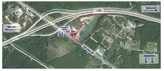
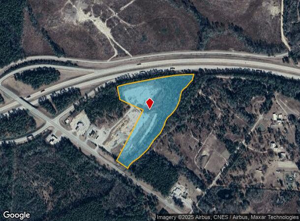
Highway 29 N
006-007A
17.96 AC HWY 29 N
Commercialacreage
Treutlen
X
Georgia
13175C0375C
17.96 AC
2024
Georgia South Area
2024
Other Market Areas
960200
DEMOGRAPHICS near Highway 29 N
1 Mile
3 Mile
5 Mile
2024 Total Population
106
615
1,536
2029 Population
105
616
1,535
Pop Growth 2024-2029
(0.94%)
+ 0.16%
(0.07%)
Average Age
40
41
42
2024 Total Households
38
241
603
HH Growth 2024-2029
(2.63%)
0.00%
(0.17%)
Median Household Inc
$61,875
$44,658
$44,999
Avg Household Size
2.30
2.40
2.40
2024 Avg HH Vehicles
3.00
2.00
2.00
Median Home Value
$65,789
$118,333
$135,065
Median Year Built
1955
1977
1981
Nearby Places
Map Layers
Map Styles
 Street
 Aerial
- Restaurants
- Banks
- Shops
- Fitness
- Groceries
SALE & LEASE HISTORY
LISTING DATE
SALE/LEASE

Oct 18, 2016
For Sale
May 09, 2019
For Sale
Nearby Properties
Address
Land Use
TOTAL SIZE
Lot Size
Zoning
Address
Land Use
TOTAL SIZE
Lot Size
Zoning
143,036 SF
123.56 AC
Address
Land Use
TOTAL SIZE
Lot Size
Zoning
1,192 SF
819.52 AC
Address
Land Use
TOTAL SIZE
Lot Size
Zoning
1,005.57 AC
RESIDENTIA
Address
Land Use
TOTAL SIZE
Lot Size
Zoning
673.81 AC
RESIDENTIA
Address
Land Use
TOTAL SIZE
Lot Size
Zoning
499.71 AC
UNZONED RU
Address
Land Use
TOTAL SIZE
Lot Size
Zoning
495.40 AC
RURAL
Address
Land Use
TOTAL SIZE
Lot Size
Zoning
402.55 AC
UNZONED RU
Address
Land Use
TOTAL SIZE
Lot Size
Zoning
368.24 AC
UNZONED RU
Address
Land Use
TOTAL SIZE
Lot Size
Zoning
5,762 SF
1.07 AC
RESIDENTIA
Address
Land Use
TOTAL SIZE
Lot Size
Zoning
217.20 AC
UNZONED RU
Address
Land Use
TOTAL SIZE
Lot Size
Zoning
2,660 SF
1.71 AC
RESIDENTIA
Address
Land Use
TOTAL SIZE
Lot Size
Zoning
1,850 SF
1.68 AC
RESIDENTIA
Address
Land Use
TOTAL SIZE
Lot Size
Zoning
232 AC
RESIDENTIA
Address
Land Use
TOTAL SIZE
Lot Size
Zoning
205.75 AC
RESIDENTIA
Address
Land Use
TOTAL SIZE
Lot Size
Zoning
212.50 AC
Address
Land Use
TOTAL SIZE
Lot Size
Zoning
140 AC
RESIDENTIA
Address
Land Use
TOTAL SIZE
Lot Size
Zoning
118.41 AC
UNZONED RU
Address
Land Use
TOTAL SIZE
Lot Size
Zoning
180.50 AC
RESIDENTIA
Address
Land Use
TOTAL SIZE
Lot Size
Zoning
1,296 SF
1.50 AC
RESIDENTIA
Address
Land Use
TOTAL SIZE
Lot Size
Zoning
168 AC
RESIDENTIA
Address
Land Use
TOTAL SIZE
Lot Size
Zoning
132.15 AC
RESIDENTIA
Address
Land Use
TOTAL SIZE
Lot Size
Zoning
130.90 AC
UNZONED RU
Address
Land Use
TOTAL SIZE
Lot Size
Zoning
110.94 AC
UNZONED RU
Address
Land Use
TOTAL SIZE
Lot Size
Zoning
2,371 SF
96.15 AC
RURAL
Address
Land Use
TOTAL SIZE
Lot Size
Zoning
1,140 SF
117 AC
RESIDENTIA
Address
Land Use
TOTAL SIZE
Lot Size
Zoning
41 AC
RESIDENTIA
Address
Land Use
TOTAL SIZE
Lot Size
Zoning
173.51 AC
RESIDENTIA
Address
Land Use
TOTAL SIZE
Lot Size
Zoning
116.20 AC
UNZONED RU
Address
Land Use
TOTAL SIZE
Lot Size
Zoning
130.12 AC
RESIDENTIA
Address
Land Use
TOTAL SIZE
Lot Size
Zoning
6,252 SF
3 AC
RESIDENTIA
The World's #1 Commercial Real Estate Marketplace
Connect with us
© 2025 CoStar Group
The information above has been obtained from sources believed reliable. While we do not doubt its accuracy we have not verified it and make no guarantee, warranty or representation about it. It is your responsibility to independently confirm its accuracy and completeness. Any projections, opinions, assumptions, or estimates used are for example only and do not represent the current or future performance of the property. The value of this transaction to you depends on tax and other factors which should be evaluated by your tax, financial, and legal advisors. You and your advisors should conduct a careful, independent investigation of the property to determine to your satisfaction the suitability of the property for your needs.